Project Status
Estimated Completion
Fall 2026Contact
Bend Bikeway Project
The Bend Bikeway Project provides safer connections for pedestrians and bicycles traveling between neighborhoods, schools, places of work, parks and trails across town.
TRAFFIC CALMING/DIVERTERS/MODAL FILTERS
- Learn more here: Frequently Asked Questions – Diverters
Tell us what you think about the newly installed Diverters/Modal Filters/Traffic Calming installations. Submit a comment form to the project team.
Information about the new diverters in these neighborhoods:
CONSTRUCTION UPDATE
Construction begins early January through Spring 2026 at the following locations:
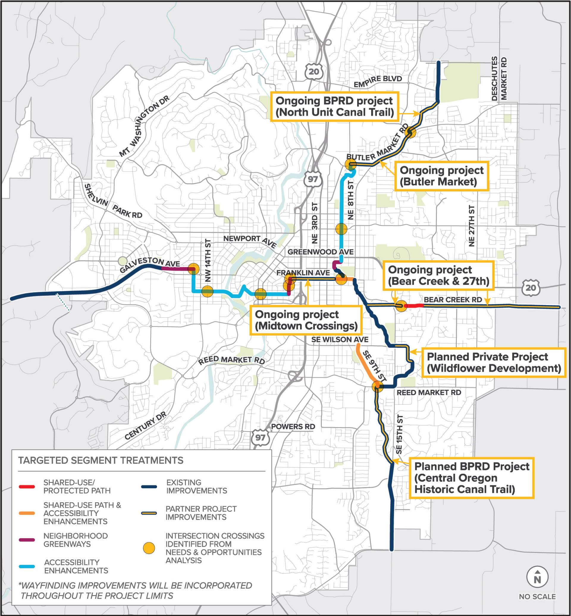
(See map below for improvement details)
– Olney Avenue & NE Sixth Street
– Hawthorne Avenue & NE Fifth Street
– Delaware Avenue & Wall Street
– Delaware Avenue & Bond Street
The City is designing a variety of safer and more accessible bike and pedestrian (routes/projects/intersections, etc.) throughout the community, including the Bend Bikeway Project that will make the most of the existing system to build one connected and protected North-South and one East-West key route.
The North-South and East-West routes are being implemented to fulfill the City Council’s 2023-2025 Transportation and Infrastructure Goal to “Implement near-term multimodal and safety projects to capitalize on the existing system, including building one connected and protected North-South and one East-West key route, and wayfinding.”
This project will identify, select, design and construct bike and pedestrian improvements that are continuous, easy to navigate and as separated from traffic as feasible. In response to feedback received at the open house and following completion of the project’s Alternatives Analysis, the project has identified improvements required to meet the goals of the project to the vision the community desires. These improvements are summarized on the interactive map linked below.
Location
Use the map below by clicking on each segment or point to see what is being proposed at those specific locations.
East-West Route
An approximate seven-mile East-West route spans from the planned Parkside Place affordable housing development in the east to the Tree Farm in the west. The planned East-West Route utilizes existing bike and pedestrian infrastructure while also relying on infrastructure that will be completed by other projects. Bend Parks and Recreation District’s existing trail network is an important component of this route. Other City projects planned to provide safe and comfortable walking and biking opportunities between east and west are also expected to construct key components of infrastructure along this route.
North-South Route
The approximate eight-mile North-South route spans from Pine Nursery Park in the north to Caldera High School in the south. The planned North-South Route utilizes existing bike and pedestrian infrastructure while also relying on infrastructure that will be completed by other projects. Bend Park and Recreation District’s (BPRD) existing and planned trail network is an important component of this route. Other projects performed by the City, BPRD and Private Development, that are planned to provide safe and comfortable walking and biking opportunities between north and south, are also expected to construct key components of infrastructure along this route.
Ninth Street Shared Use Path
An approximate 0.6-mile shared use path adjacent to Ninth Street between SE Reed Market Road and SE Wilson Avenue.
Schedule
The goal is to complete the installation of these routes by end of fall 2026. Please note that portions of these routes are also being completed by other by other private and public projects, so the timing of these projects could also impact when these cross-town routes are finished.
Project Design
- Use interactive map above to learn more about designs for each location.
- Watch video presentation (above) for overview of design at each location.
Public Meetings
FEB 2024 OPEN HOUSE SUMMARIES
Thank you for taking the time to help shape the Bend Bikeway project! Key takeaways from this round of public engagement include:
- The community desires shared streets to offer a higher level of service than the existing neighborhood greenway routes by further limiting vehicle speeds and volumes and to offer more protection than “just paint” to set a better baseline for Bend’s Bikeways that would lead to increased use.
- The project team has identified locations for traffic diverters that would further reduce vehicle traffic on existing neighborhood greenways. We will share these plans with the Neighborhood Districts to ensure the proposed plans fit into their respective neighborhoods.
- Many prefer routes that separate users from vehicle traffic to the maximum extent possible while also creating the most direct routes, noting that these improvements are generally seen as being worth the added costs and potential impacts to adjacent properties.
- Due to this feedback, the City has selected a preferred Franklin Avenue (from 5th Street to 8th Street) design alternative that was not presented during this open house event but better meets the goals of the project. This alternative can be seen on page 8 of this presentation. It considers separated bike and pedestrian facilities on each side of the road.
- The City has also identified two locations where additional shared-use paths would help meet the goal of this project to the community’s expectation; however, these routes are currently outside of the project’s approved scope of work.
- People want bike infrastructure that is better maintained, landscaped and lit.
- The City will strive to incorporate landscaping and illumination elements into the design of this project to the extent possible given the existing constraints to ensure improvements are safe and fit within the aesthetic of their surroundings.
- This open house event helped the City collect information about locations along the Bend Bikeway routes where people feel unsafe.
- The project team will share plans to make improvements at select locations with the Neighborhood Districts, however funding limitations will also impact the extent of unsafe locations that can be treated with this project.
- Open house attendees were excited about new bike infrastructure the City is planning but is not sure how all the planned projects would be tied together, or when a project would be constructed along their daily routes.
- The City is still working to develop the entire network of Key Bicycling and Walking Routes.
- The bond dashboard is available to track how the City is developing these Key Bicycling and Walking Routes.
- During the open house period, the project team provided an overview of the project to the Council’s Community Building Subcommittee at the February 28, 2024 meeting.
- A recording of this presentation can be found here and the presentation overviews the shared-use path concepts that were shown at the open house, the new Franklin alternative that was not shown at the open house, examples concepts being considered for new Neighborhood Greenway / shared street corridors, and a few of the possible design contract additions. The presentation also provides an updated overview of the project’s schedule and financial resources.
- Design Update Informational Online Open House
Dec. 16, 2024 – Jan. 2, 2025
- Open House and Survey (In person-Feb. 29, 2024; Online Feb. 21 – Mar. 6, 2024)
The open house and survey closed on Mar. 6, 2024. However, feel free to browse the open house exhibits and summary information below.
Dec. 16, 2024 – Jan. 2, 2025
This open house comment period is now closed. However, you can still browse the open house information on the interactive map (instructions below) and view the general project update information.
Explore the project’s current designs available to view on the project map, where you can take a virtual tour by clicking on a segment or intersection to learn about the planned improvements.
The Bend Bikeway project will make improvements to enhance the safety and enjoyment of walking and biking for everyone in our community. The Bikeway includes two separate components:
- The SE 9th Street project focuses on constructing a shared-use path between Reed Market Road and Wilson Avenue, with a budget of $1.15 million.
- A North-South and East-West route will utilize a combination of existing improvements and ongoing City plans to create connected and protected routes, with a budget of $2.37 million.
These segments take advantage of ongoing City projects, connecting pathways and making them safer for people walking and biking between neighborhoods, schools, places of work, parks and trails across town. The Bend Bikeway is just one of many improvements planned to ultimately develop the Transportation System Plan network of key walking and bicycle routes that aim to offer a comfortable commuting and recreational experience for users of all ages.
The timing of the Bikeway construction will depend upon the completion of other ongoing private and public projects, with most of the routes expected to be complete by fall 2025.
Improvements made with this project will include shared use/protected paths, neighborhood greenways, intersection enhancements, accessibility enhancements (such as sidewalks, safe crossings, and curb ramps) and signage. A map showing which types of improvement will be targeted for each segment of the routes is shown below. The exact locations of improvements along these segments are still to be determined.
Open House Goals
The City is proud to share initial design efforts and welcomes community feedback that will help shape Bend’s biking and walking future!
To help us make decisions, the City wants to hear about locations where you currently feel unsafe along these routes, your use of the routes and what design elements you think should be prioritized with the available funding. There are two separate tools available at this online open house for you to provide feedback; the Bend Bikeway Public Feedback Map tool and the Bend Bikeway Open House Survey. These public engagement opportunities can be accessed at the bottom of this Online Open House page.
Initial design efforts have been focused on segments where shared use/protected paths are being considered. Shared use/protected paths offer users a high level of comfort, however, these improvements also come at a high cost. As such, shared use/protected paths are only being considered along the highest volume areas of the routes. The following sections outline what types of shared use/protected paths improvements are being considered along 9th Street (Reed Market Road to Wilson Avenue), Franklin Avenue (5th Street to 8th Street) and Bear Creek Road (15th Street to Cessna Drive).
Click on Tabs below to browse exhibits and share feedback.
The open house survey and feedback map are closed.
The interactive feedback map and community survey closed March 6, 2024.
Background
The East-West and North-South routes are directly linked to City Council’s 2023-2025 Transportation and Infrastructure Goal that is intended to “Implement near-term multimodal and safety projects to capitalize on existing system, including building one connected and protected North-South and one East-West key route, and wayfinding.” The NS and EW Routes being considered were discussed and recommended through the following meetings:
- May 25th, 2023 Community Building Subcommittee
- May 30th, 2023 Transportation Bond Oversight Committee Quarterly Meeting
- June 21st, 2023 City Council Work Session
The Ninth Street Shared Use Path was identified to fill in a gap in the key walking and bicycling routes during the City’s community-driven Transportation System Plan update, undertaken between 2018- 2020. The Transportation System Plan was adopted by Bend City Council and projects from the plan, including this one, were included in the Transportation General Obligation Bond passed by Bend voters in November 2020.