Midtown Pedestrian and Bicycle Crossings Feasibility Study – Open House
This open house concluded on July 3, 2022. Feel free to browse through the information and exhibits below.
Open House Survey Results
Project Overview
Project Background and Description
The Midtown Pedestrian and Bicycle Crossings project is a City of Bend led effort to identify safer walking and biking connections between east and west Bend and potentially construct one or more improved crossings of U.S. 97 (Bend Parkway) and Burlington Northern Santa Fe (BNSF) railroad at the following corridors:
- Greenwood Avenue existing undercrossing
- Franklin Avenue existing undercrossing
- Hawthorne Avenue crossing
During the City’s Transportation System Plan (TSP) and Core Area Project (CAP) the community identified a need and desire for safer and better connections for walking and biking in these corridors across U.S. 97 and the railroad which led to the creation of this project. Then in 2020 voters approved funding for the project through the City’s Transportation GO Bond which is providing more than $12 million.
The first step in this project is a feasibility study. The study will identify what’s possible, implement a strategy for making the improvements happen and give recommendations on construction timing, needs and costs.
Feasibility Study Open Houses
The project team is sharing preliminary design concepts for each crossing and ask for community feedback.
- ONLINE OPEN HOUSE: June 13-July 3, 2022
- IN PERSON OPEN HOUSE: June 22, 2022 | 5-7 p.m., Open Space Event Studios, 220 NE Lafayette Ave. It is a drop by any time format. There is no formal presentation. However, please note the information shared at the in-person open house will be the same as what is available online.
Help Guide the Project
This open house is your opportunity to give feedback on the feasibility study and help inform the project’s next steps after the study which may include selecting one or more locations for design and construction.
Below, under each of the project’s study locations, you will see a series of alternatives. Please review each alternative including the concept graphics, descriptions, benefits, and drawbacks. Then complete the survey question under each alternative to vote for your preferred alternative. An open-ended comment box is also provided under each location if you would like to leave feedback for the project team.
At the end of this page there are additional survey questions. One allows you to help guide the project beyond the feasibility study by voting for which location or corridor you would like to see move forward first if funding is not available for all three, which is very likely. Finally, there is an additional open-ended comment box if you would like to leave any last general feedback for the project team.
Thank you for visiting!
Preliminary Design Concepts
Go directly to the study locations by using the tabs below and tell us your thoughts.
Design Concepts: Greenwood Avenue Undercrossing
EXISTING CONDITIONS
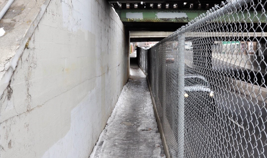 The existing undercrossing on Greenwood Avenue is dark and hard to see from one end to the other. Currently, people walking and biking share a narrow, raised sidewalk with a chain link fence separating them from the vehicle traffic below.
GREENWOOD DESIGN CONCEPT 1: Shared-Use Path Improvements
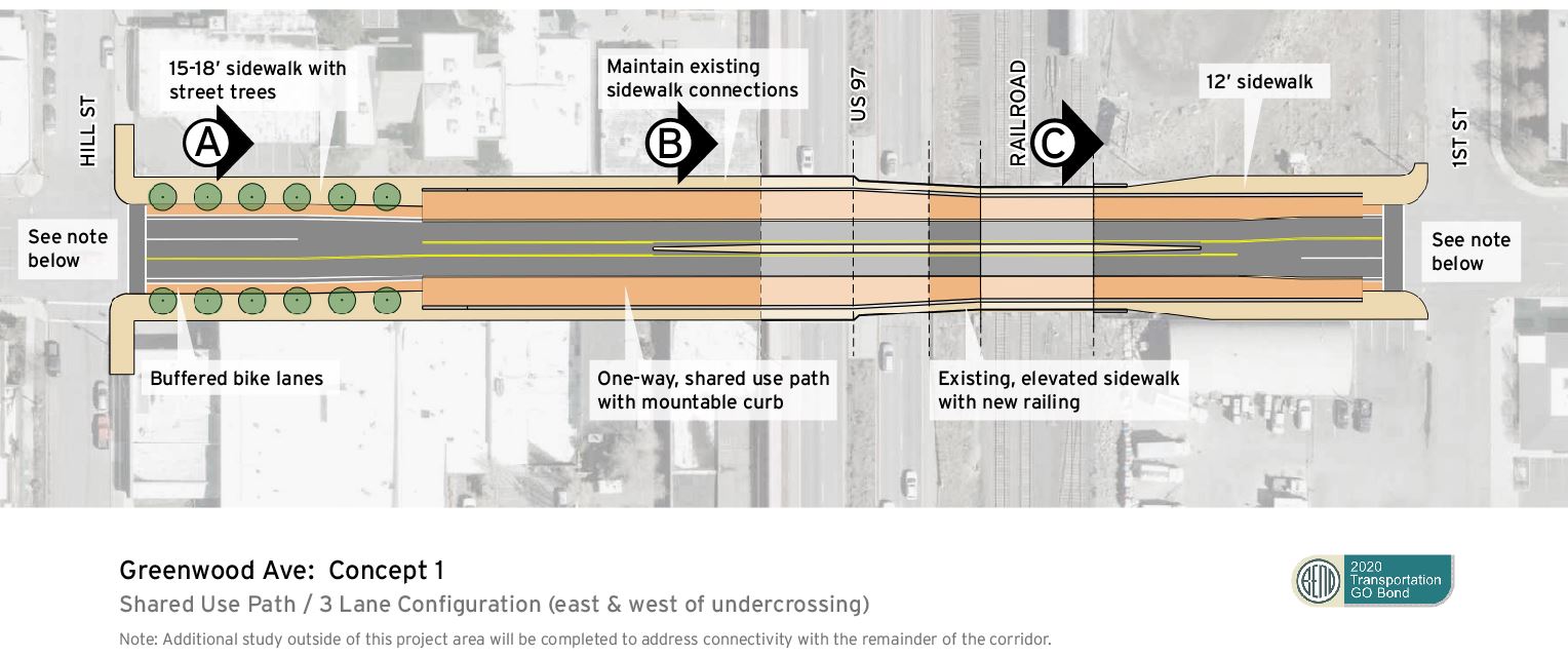 Select the letter below to view the roadway area cross section:
![]()
![]()
![]()
This design concept adds a shared-use path on both sides with a mountable curb separating vehicle traffic from the path. The existing sidewalk remains the same with an upgraded railing. The current four-lane traffic configuration will change to three lanes to allow space for the shared-use path. The mountable curb allows for emergency vehicle access.
The road section will transition on both sides of the undercrossing to allow for a left turn lane at NE First Street and NW Hill Street.
LEVEL OF IMPROVEMENT, COST AND TIMELINE
- Level of Improvement: Minimal. This concept improves some safety issues for Greenwood Avenue without having to change the existing sidewalk or under-pass structures.
- Cost: Low. Initial assessments put this on the low-end of possible design concepts.
- Timeline: Low. The lower cost could allow the City to move forward with available funding and implement changes in the next one to two years.
BENEFITS
- The wide shared-use path provides safety and mobility for people walking and bicycling.
- Less complex including faster permitting process and construction timeline.
- Enhances separation between the shared-use path and vehicle travel lanes.
- A mountable curb on the shared-use path allows emergency vehicle access.
DRAWBACKS
- No direct access to first several businesses on west side of undercrossing from shared-use path.
- Additional drainage facilities are needed for stormwater and snowmelt.
- Shared-use path will follow the road profile and will be steeper than the existing walkway.
- Does not provide a dedicated bike lane.
GREENWOOD DESIGN CONCEPT 2: Lower and Widen Sidewalks
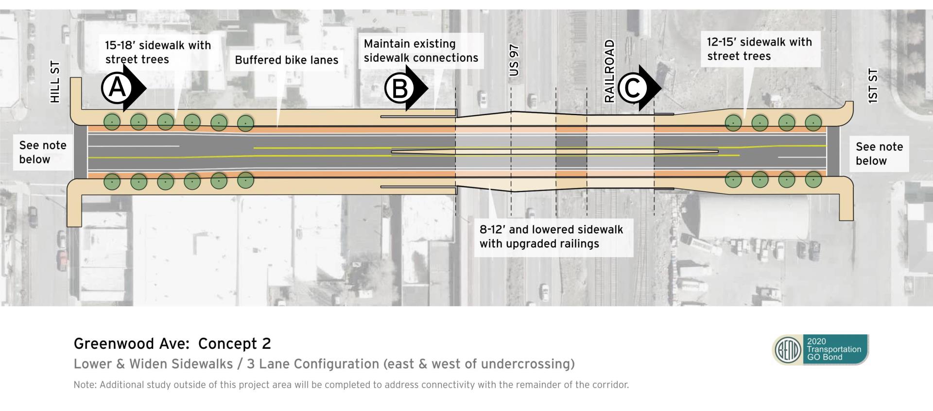
Select the letter below to view the roadway area cross section:
![]()
![]()
![]()
This design concept partially lowers and widens the sidewalks for people walking. The current four-lane traffic configuration will change to three lanes to allow for the widened sidewalk. The center turn lane will end before the underpass to accommodate the existing structural supports. The buffered bike lane has the required width to accommodate emergency vehicles.
Download Concept 2
LEVEL OF IMPROVEMENT, COST AND TIMELINE
- Level of Improvement: Moderate. This concept improves some of the safety issues for Greenwood Avenue without having to complete an expensive rebuild of the undercrossing.
- Cost: Mid-range. Initial assessments put this in the mid-range of possible design concepts.
- Timeline: Moderate. The moderate cost could allow the City to move forward with secured funding and implementing improvements faster.
BENEFITS
- Provides safer, more visible and accessible routes for people walking and bicycling.
- Widens and lowers the existing sidewalk path to make a safer and more comfortable experience for people walking and bicycling.
- Provides buffered bike lanes as a dedicated route for increased safety.
- Access to businesses on west side of undercrossing is similar to existing conditions.
DRAWBACKS
- Complex construction process due to removal of walls and lowering and widening of the walkway.
- Potential longer permitting process due to ground disturbance.
- Longer construction timeline and high impact to people traveling through underpass during construction
- Additional drainage facilities needed for stormwater and snowmelt.
WHAT YOU NEED TO KNOW
- CONCEPT 1: Shared-Use Path Improvements will fix the minimum safety concerns but is the cheaper and faster option.
- CONCEPT 2: Lower & Widen Sidewalks will fix most safety concerns but will cost more or take longer to complete.
- BOTH CONCEPTS: The City has conducted an initial engineering study to begin looking at the considerations and trade-offs of different roadway lane configurations on Greenwood Avenue in this area that could support either of these concepts. A link to the study is available for review below. However, additional public outreach and engagement would be conducted before any changes are made to the corridor.
Tell us what you think
Design Concepts: Hawthorne Avenue Pedestrian and Bicycle Crossing
EXISTING CONDITIONS
Currently Hawthorne Avenue does not cross US 97 (Bend Parkway) and the BNSF railroad. However, the City’s Transportation System Plan (TSP) and Core Area Project (CAP) that included extensive public outreach and engagement identified that a new pedestrian and bicycle crossing at this location could support community goals for future urban housing and employment needs. An investment at this location also presents an opportunity for the NE 3rd Street commercial strip and nearby industrial area to transition to a mixed-use area where people can live, work and play. Finally, constructing an entirely new crossing here versus modifying the existing ones at Greenwood and Franklin may be quicker to implement in the near term, depending on the design chosen and cost.
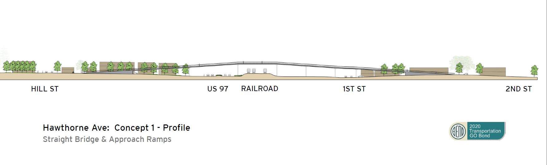
HAWTHORNE DESIGN CONCEPT 1: Bridge with Long Ramps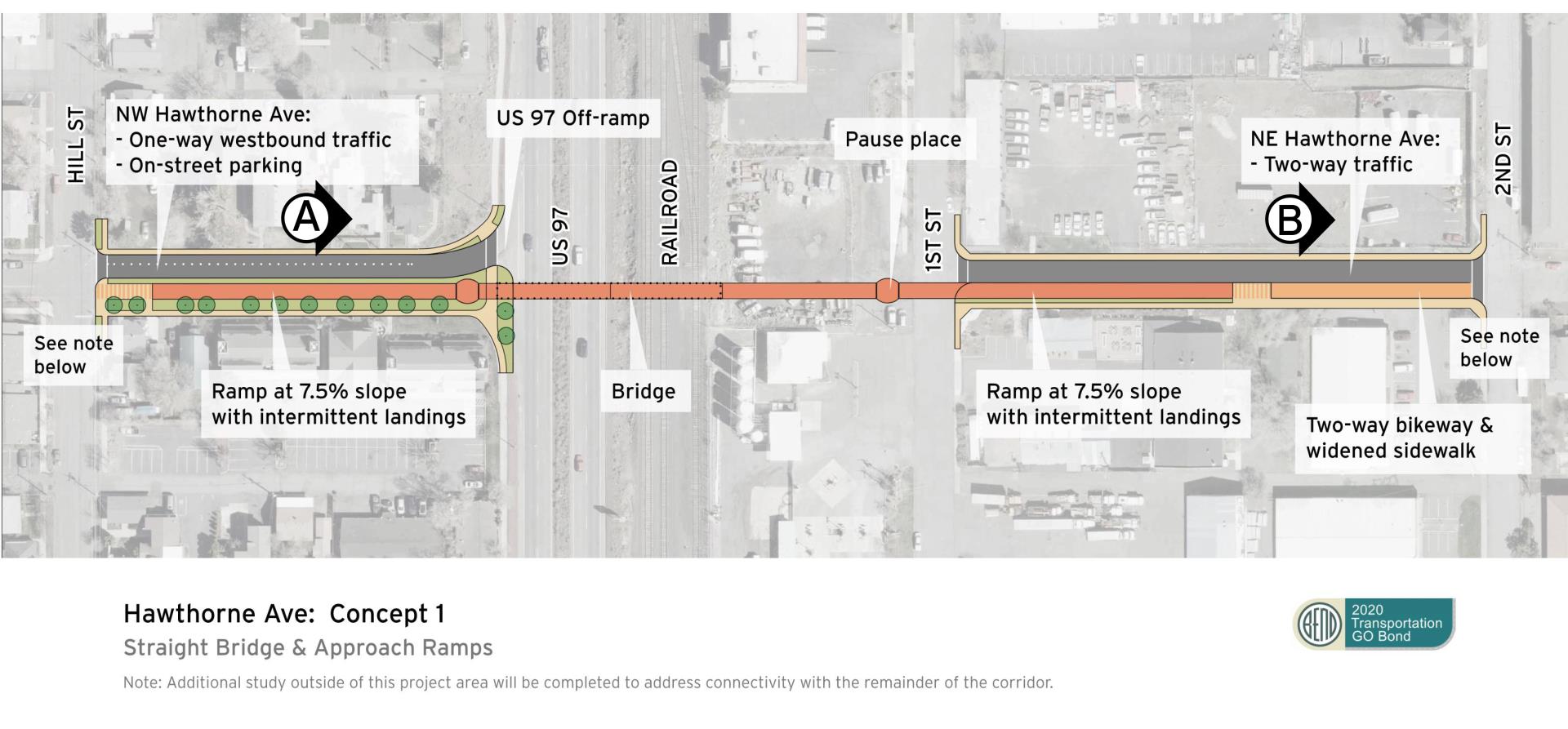
Select the letter below to view the roadway area cross section:
![]()
![]()
This design concept features a bridge with long ramps located on the south side of Hawthorne Avenue. To accommodate a bridge tall enough to span U.S. 97, the ramps will include slopes up to a 7.5% grade – that means the ramps will rise seven feet every 100 feet – with a few landings to rest or slow wheels. The west ramp stops short of NW Hill Street and allows for a flat area before the intersection. The east ramps end at the high point on Hawthorne Avenue.
LEVEL OF IMPROVEMENT, COST AND TIMELINE
- Level of Improvement: Significant. This concept provides a simple and direct route for people walking and bicycling and meets accessibility requirements.
- Cost: High. Initial assessments put this in the low-range of possible Hawthorne Crossing concepts.
- Timeline: Moderate. The moderate cost could allow the City to move forward with secured funding and implementing improvements faster.
BENEFITS
- Clear direct route for people walking and bicycling.
- Establishes universal accessibility.
- No blind spots for bridge users.
- Opportunity for views in all directions from bridge deck.
- The elongated bridge and ramps create more opportunities for a creative and iconic design, and a sleek and minimalist structure.
- No stairs or elevators required.
- Minimal maintenance.
- The 7.5% ramp grade with landings will help slow down bicyclists.
- Least expensive Hawthorne Crossing option without elevators.
- The west ramp utilizes space freed up by a proposed closure of the U.S. 97 entrance access (U.S. 97 exit access to remain open)
DRAWBACKS
- High railroad clearances require long ramps.
- Ramp structure obstructs views at the street level from properties along NW Hawthorne Avenue between NW Hill Street and NW Second Street.
- East ramp eliminates parking on both sides between NW 1st Street and NW 2nd Street.
- Some vehicle access to properties along the west side of NW Hawthorne Street may be impacted or eliminated.
- The ramp grade at 7.5% with landings might be more difficult to climb for some users.
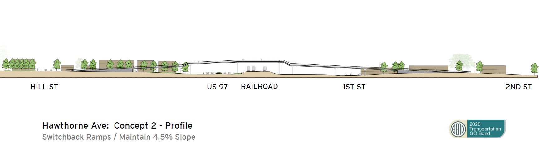
HAWTHORNE DESIGN CONCEPT 2: Bridge with Switchback Ramp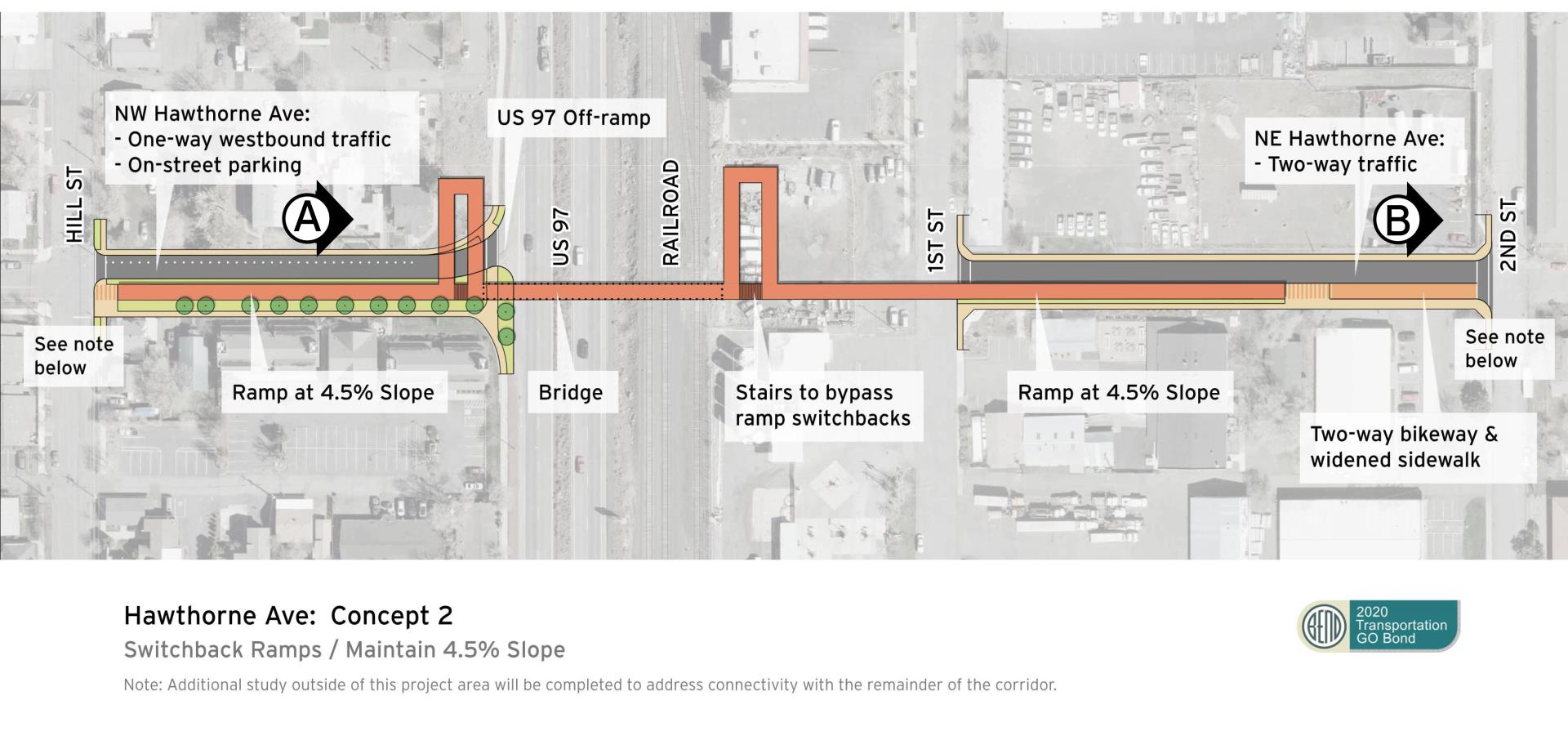
Select the letter below to view the roadway area cross section:
The “Bridge With Switchback Ramps” is like the “Bridge with Long Ramps” Concept, but it features ramps with switchbacks for a more comfortable slope – or 4.5% grade. This design might be able to accommodate stairs between the switchback loops to allow people walking to bypass the switchbacks.
The west ramp would be routed onto the City-owned property and back to the south side of NW Hawthorne Avenue. The proposed ramp location would not impact ODOT’s ability to lengthen the deceleration lane for the U.S. 97 exit to Hawthorne Avenue in the future.
LEVEL OF IMPROVEMENT, COST AND TIMELINE
- Level of Improvement: Significant. This concept provides a more complex but direct route for people walking and bicycling and meets accessibility requirements. The slope of the approach ramps is more gradual and comfortable for users.
- Cost: High. Highest of three Hawthorne Crossing concepts.
- Timeline: Significant. The cost may require more time for the City to fully fund, design and construct the bridge.
BENEFITS
- Clear direct route for able-bodied pedestrians.
- Establishes universal accessibility.
- Opportunity for views in all directions from bridge deck.
- Ramp slopes are more gradual (approximately 4.5%).
- No elevators required.
- Stairs at switchbacks provide a direct route for some users.
- The west bridge ramp utilizes street space freed up by a proposed closure of the U.S. 97 entrance (U.S. 97 exit access to remain open).)
DRAWBACKS
- High railroad clearances require extensive ramping and longer travel distance for users unable to use stairs.
- The ramp structure will obstruct street-level views from some properties along NW Hawthorne Avenue between NW Hill Street and NW Second Street.
- Ramps and switchbacks will block views across the street and U.S. 97.
- Switchbacks create a bulkier structure that will be visible from U.S. 97 and may detract from the signature look of the bridge.
- Snow removal on stairs is more difficult.
- East ramp eliminates parking.
- Existing vehicle access to properties along the west side of Hawthorne Avenue may be impacted or eliminated.
HAWTHORNE DESIGN CONCEPT 3: Bridge with Stairs and Elevator Access (No Ramps)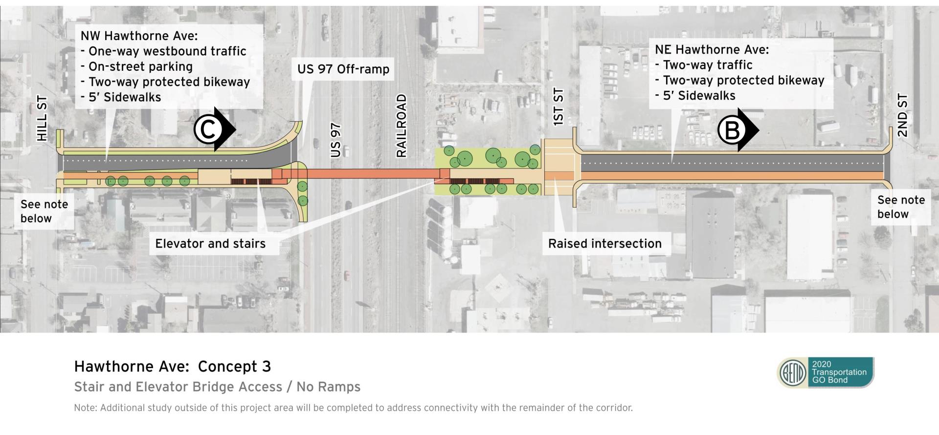
Select the letter below to view the roadway area cross section:
The “Bridge With Stairs and Elevator Access (No Ramps)” concept features an elevator and stairs but does not include ramps. This allows the potential for the development of a plaza area between the elevator and NE 1st Street and a multi-use path on the south side of Hawthorne Avenue between NE 1st Street and NE 2nd Street.
The elevator and stairs would be located close to the railroad and ODOT’s Right-of-Way. The approach to the elevator on the west side of U.S. 97 would slope up to create a vertical separation between the highway deceleration lane and the multi-use path approaching the elevator.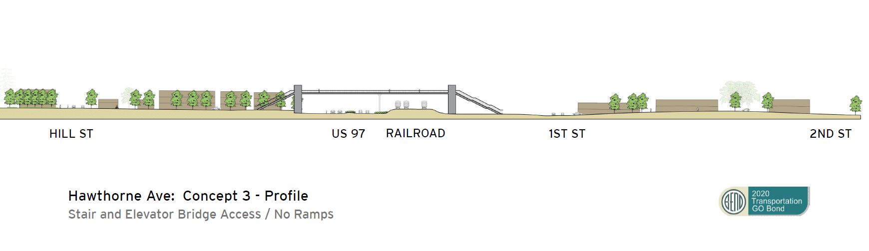
LEVEL OF IMPROVEMENT, COST AND TIMELINE
- Level of Improvement: Significant. This concept provides a direct route for people walking and bicycling with the use of stairs and an elevator.
- Cost: High, but the middle of the three Hawthorne Crossing concepts.
- Timeline: Significant. While the cost is estimates as the middle of the bridge alternatives, the City would need time to fully fund, design and construct the bridge.
BENEFITS
- Establishes a clear route for access that the community can easily understand.
- Establishes universal accessibility.
- Provides clear and safe connections.
- Utilizes the smallest footprint to accommodate the crossing.
- Minimal roadway impacts during construction.
- No visual obstruction from ramp structure; preserves the street character and sightlines from properties along Hawthorne Avenue between NW Hill Street and NW 2nd Street.
- Lower anticipated construction costs.
- Gives opportunity for a higher main span elevation if this is advantageous for views from the bridge and/or signature bridge design.
DRAWBACKS
- Requires long-term elevator maintenance and repairs.
- Personal safety and sense of security concerns because of enclosed spaces or blind spots at stairs and elevators.
- Snow removal on stairs and bridge is more difficult.
WHAT YOU NEED TO KNOW
- Concept 1: Bridge with Straight Ramps. The cost of this concept is expected as the lowest of the bridge options. Ramps will be shorter than Concept 2 and therefor will be steeper and might be more difficult for some users.
- Concept 2: Bridge with Switchback Ramps. This is the most expensive of the alternatives but increases the length of the ramps and reduces the slope making the climb easier for some users.
- Concept 3: Bridge with Stairs and Elevator Access (No Ramps). Cost for this concept is anticipated to be between Concept 1 and 2. This concept is the smallest footprint of the three concepts but will require people to use the stairs or take an elevator.
- All concepts: Additional work is still needed beyond this feasibility study to ensure connectivity for safe walking and bicycling from surrounding neighborhoods to this crossing to connect Juniper Park to Downtown.
All three concepts may require additional time to fully fund, design and construct.
Tell us what you think.
- Hawthorne concepts survey questions – SURVEY CLOSED
- Avenida Hawthorne
Design Concepts: Franklin Avenue Undercrossing
EXISTING CONDITIONS
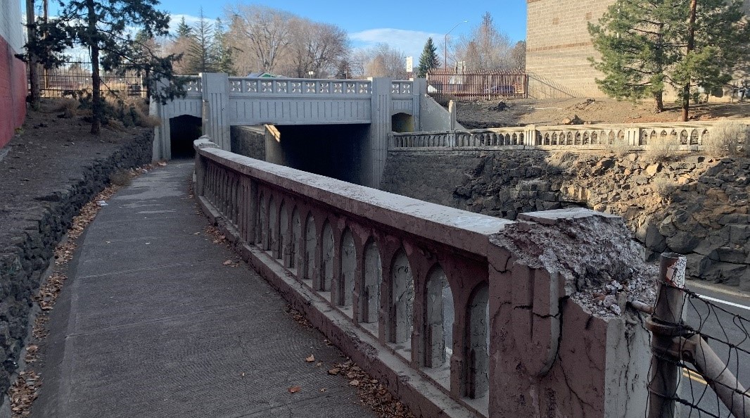 The existing undercrossing on Franklin Avenue is very narrow and dark, and it’s hard to see from one end to the other. It is currently used by more people walking and biking than the Greenwood Avenue undercrossing, including Bend Senior High School students.
FRANKLIN DESIGN CONCEPT 1: Widen and Level East Access Only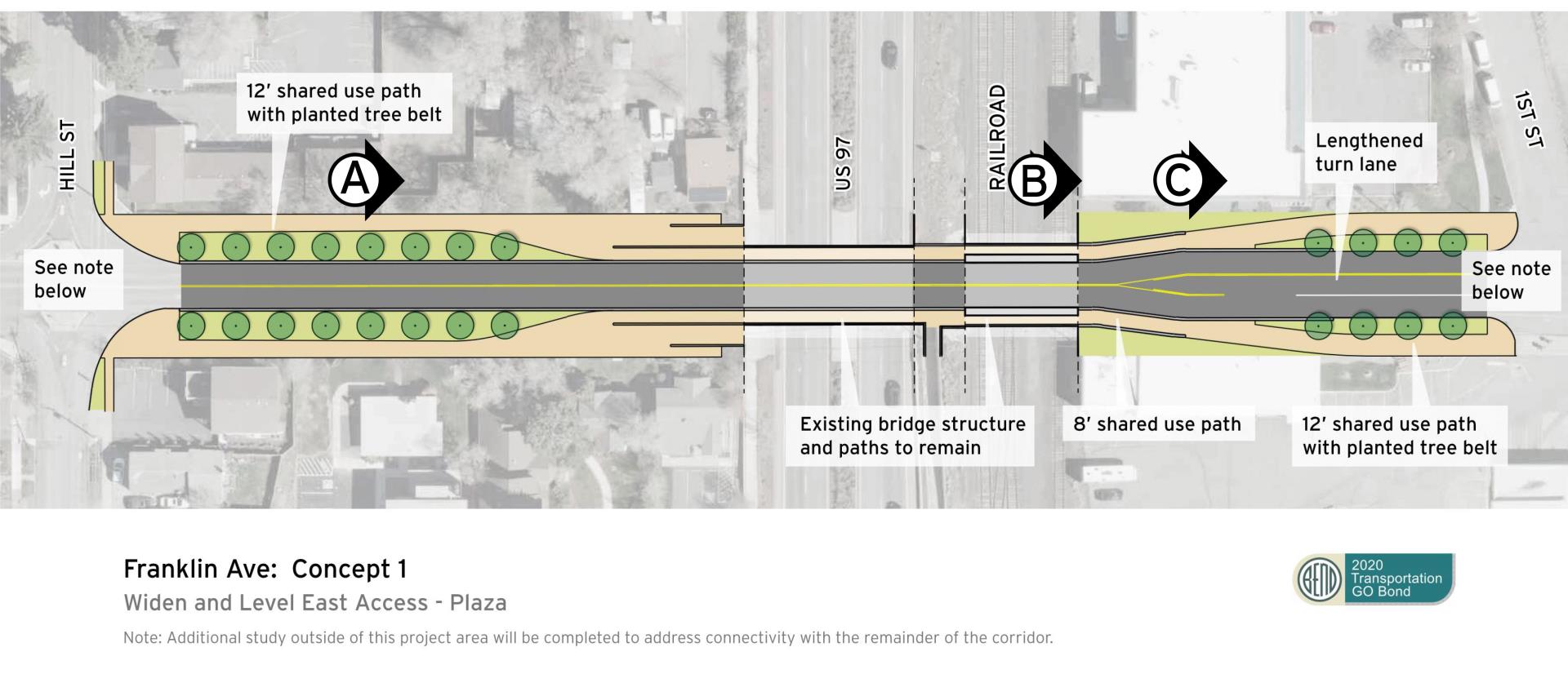
Select the letter below to view the roadway area cross section:
![]()
![]()
![]()
This design concept will widen the openings on the east side of the crossing only. This will moderately improve the line of sight (in and out of tunnels, lighting, accessibility, and better accommodate people walking and biking within the same space.
LEVEL OF IMPROVEMENT, COST AND TIMELINE
- Level of Improvements: Moderate. This concept improves some of the safety issues for the Franklin Avenue undercrossing including improving visibility and lighting. It also replaces the retaining wall to create more room for people walking and biking within the same space.
- Cost: Moderate. Initial assessments put this in the mid-range of the Midtown Crossings design concepts.
- Timeline: Moderate. The moderate cost could allow the City to move forward with securing funding and implementing improvements faster.
BENEFITS
- Improves sightlines, safety, mobility, and comfort on paths approaching undercrossing from the east.
- Provides streetscape improvements on both sides of the undercrossing.
- Improves visibility into existing rail and highway underpasses.
- Less complex construction process.
- Shorter permitting and construction timeline.
- Maintains existing mural.
DRAWBACKS
- Does not provide any improvements for people walking or bicycling in the undercrossing.
- Does not address substandard path width and personal safety concerns of the undercrossing.
FRANKLIN DESIGN CONCEPT 2: Full Rebuild and Widening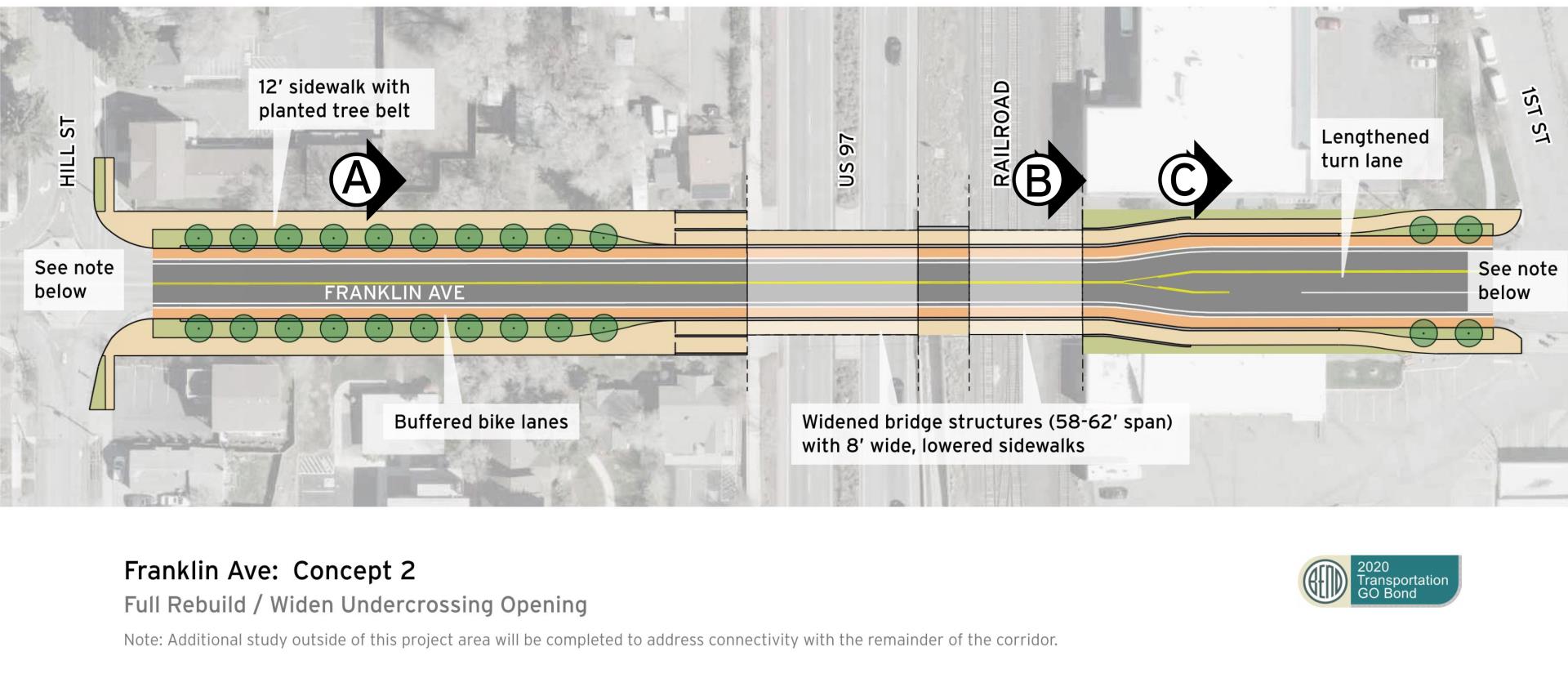
Select the letter below to view the roadway area cross section:
![]()
![]()
![]()
This design concept will rebuild and widen the undercrossing allowing for a standard two-lane road with separated sidewalk and bike lines on both sides. The sidewalk may need to remain raised above the street to maintain a gentler slope and meet accessibility requirements.
LEVEL OF IMPROVEMENT, COST AND TIMELINE
- Level of Improvements: Significant. This concept improves almost all safety issues for the Franklin Avenue undercrossing including improving visibility and allowing plenty of room for people walking and bicycling.
- Cost: High. Initial assessments put this at the same cost as the most expensive Hawthorne crossing concept.
- Timeline: Significant. The higher cost will require more time for the city to find funding and to implement improvements.
BENEFITS
- Provides enough width to allow for standard widths for sidewalks, bike lanes and vehicle lanes.
- Improves safety and visibility for people walking and bicycling.
- Eliminates current tunnels and safety and visibility concerns.
- Greatly improves safety, mobility, and comfort of everyone traveling through undercrossing.
- Provides a separate and dedicated space for people driving walking and bicycling.
- Provides streetscape improvements on both sides of the undercrossing.
DRAWBACKS
- Complex construction due to replacement of both bridges and associated walls.
- Long construction process with significant temporary traffic impacts during construction on both Franklin Avenue and U.S. 97.
- Long permitting process.
- Removal of existing murals, though there may be opportunities for future murals.
WHAT YOU NEED TO KNOW
- Concept 1: Widen & Level East Access Only will fix some, but not all safety concerns. However, it is likely cheaper and faster to complete.
- Concept 2: Full Rebuild & Widening will fix almost all safety concerns, but it will cost more and take longer to complete.
- Both concepts: Additional work is still needed beyond this feasibility study to ensure better conditions for walking and bicycling along the Franklin Avenue corridor to and from the crossing location.
Tell us what you think
- Franklin concepts survey questions – SURVEY CLOSED
- Avenida Franklin
Este proyecto identificará oportunidades para mejorar la conectividad este-oeste a través de conexiones más seguras para caminar y andar en bicicleta en el área central de Bend. Los resultados de las preguntas de la encuesta se publicarán en este sitio web. Se presentará un informe final al Ayuntamiento y se publicará en el sitio web del proyecto al finalizar el estudio de factibilidad. Si tiene más preguntas, escriba a midtownxings@bendoregon.gov
- Enlace a la jornada de puertas abiertas y preguntas de la encuesta
- La Jornada de puertas abiertas completa
- Greenwood- Concepto de diseño 1
- Greenwood- Concepto de diseño 2
- Hawthorne – Concepto de diseño 1
- Hawthorne – Concepto de diseño 2
- Hawthorne – Concepto de diseño 3
- Franklin- Concepto de diseño 1
- Franklin- Concepto de diseño 2
What happens next?
The results of the survey questions are posted on this website (top of page). A final report will be presented to City Council and posted to the project website at the conclusion of the feasibility study.
You can learn more about the project
- Visit bendoregon.gov/midtowncrossings for the project timeline and more information.
- Come to the In Person Open House* on June 22 from 5-7 p.m.
at Open Space Event Studios, 220 NE Lafayette Ave.
* The information shared at the in-person open house will be the same as what is available online.
Don’t see a design concept you think should be studied?
The project team considered a wide range of alternatives prior to this open house. To review which ones didn’t make the list and why, please see the Initial Screening Analysis.